PHOTOGRAPHY & WRITING
THE SWEDISH WEST COAST:
LAND OF ROCK
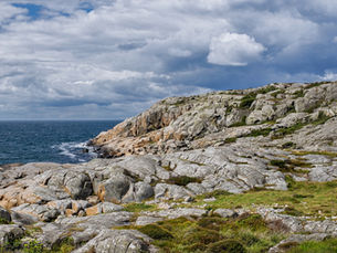
As it descends from the Norwegian border, Sweden’s west coast winds tight ribbons around rocky fjords, peninsulas, and islands. Knolls of granite and gneiss sculpted by long-vanished sheets of ice slope seaward along the coasts of Bohuslän and northern Halland. Farther south, rocky outcrops increasingly mingle with sandy beaches, salt marshes, and open pastures. In both its sweeping vistas and quiet corners, the rocky coastline reveals a landscape at once richly varied and austere, sparing and serene.

The coastal bedrock of western Sweden began forming around 1.7 billion years ago on the margins of the Baltic Shield, the ancient geological core of Scandinavia. The shield expanded in size over time through collisions with other landmasses that migrated across earth’s primordial seas. These collisions triggered two major mountain building episodes during which new magma welled up from within the earth’s crust and older rocks were intensely reworked and transformed. As the earth’s crust wrinkled up and thickened, surface rocks were buried deep underground, where extreme heat and pressure melted, deformed, and recrystallized them into vast masses of gneiss, especially prominent along the coast of Halland.
Younger rock formations mainly appear in northern Bohuslän, where sweeping expanses of weathered granite dominate the coast. Around 900 million years ago, molten granite intruded into older, mostly gneissic bedrock. The Bohus granite cooled slowly beneath the surface to form a coarse-grained rock that glacial ice later polished into the region’s characteristic rounded reddish and grayish humps. These rocks lay buried deep beneath the surface for eons, but were eventually exposed by tectonic upheavals that uplifted the land and erosion.
Today, the coastal rockscape is a place of captivating contrasts. Flowing streaks and bands of light and dark rock reveal the drama of a once-molten underground world. Billowing ovals of granite cradle fragments of black-and-white gneiss or are laced with bold veins of pegmatite, a coarse-grained granite with exceptionally large crystals. Even on outcrops that appear uniform from a distance, intricate mineral patterns, vivid cliques of lichen, and striking variations in the hue and texture of the rock draw the eye from up close.1

All along the coast, just beyond the ordinary reach of waves, small plants find refuge amid bold swaths of wind-scoured stone. Goldmoss stonecrop and rock campion cluster in sheltered crevices while along the edges of pools and marshy dips, bog bilberry, sweet gale, creeping willow, and cottongrass create painterly washes of color. Elsewhere, bare humps of granite and gneiss descend into bristly shags of common heather and black crowberry—hardy, low-growing shrubs well-adapted to thin coastal soils—or into soft mats of grass dappled in sea thrift.
The grassy mats and heathers bear witness to the coast’s long history of human use. Evidence of human settlement stretches back to the Bronze Age, and in some places earlier. As permanent villages emerged, farmers grazed their livestock on shared coastal pastures. Grazing encouraged the spread of open heathlands, which were burnt regularly to stimulate new growth on the heathers. By removing taller, faster-growing plants, grazing also allowed tiny, sun-loving flowers and herbs to thrive. The result was a richly textured mosaic of low vegetation that supported a wealth of insects and birds.2
This ecological legacy has largely disappeared with the decline of coastal grazing since the late 1800s. Yet in many of the nature reserves featured in the images here, efforts to reintroduce grazing and controlled burning are helping to revive the biological richness of a bygone cultural landscape. Whether I wander across a grassy carpet or barren outcrop of rock, even in its starkness and grandeur, the coast offers a mesmerizing intimacy and softness.

SOURCES
Geology
Andersson, Jenny, Charlotte Möller, Inger Lundqvist, Mehrdad Bastani, and Ildiko Antal Lundin. 2019. Beskrivning till berggrundskartan Falkenberg (Description to the Bedrock Map Falkenberg). Geological Survey of Sweden: 17-20.
Bohusgraniten, Sweden’s youngest bedrock. Svenneby Hembygdsförening. (Last updated 2025-04-07 15:12:56.) https://www.hembygd.se/svenneby-hembygdsforening/ny-sida-14.
Geological Survey of Sweden. The bedrock of Sweden. (Last reviewed 2020-09-22.) https://www.sgu.se/en/geology-of-sweden/rocks/the-bedrock-of-sweden/
Granitlandskapet (the Granite Landscape). Stångehuvud. https://www.stangehuvud.se/Granitlandskapet.htm
Gustavson, Karl-Olov. 2019. “Bergrunden” (Bedrock). In Kjell Georgsson et al., Hallands Flora. Svensk Botanisk Tidskrift (Swedish Botanical Journal).
Lundqvist, Inger and Leif Kero. 2008. Beskrivning till berggrundskartan 5B Varberg NO (Description to the Bedrock Map 5B Varberg NO). Geological Survey of Sweden: 5-9.
Slagstad, Trond et al. “Regional Geology (pp. 2-3). The Sveconorwegian orogeny – Reamalgamation of the fragmented southwestern margin of Fennoscandia, Precambrian Research, v. 350, November 2020.
Natural Grazing and Flora
Ekstam, Urban and Nils Forshed. 2000. Svenska Naturbetesmarker: historia och ekologi (Swedish natural pastures: history and ecology). Naturvårdsverkets Förlag.
Frisk, Michael and Krister Larsson. 1999. Agrarhistoriska Landskapsanalysis över Hallands Län (Agrarian Historical Landscape Analysis of Halland County). Landskapsprojektet 1999: 7. Riksantikvarieämbetet, Informationsavdelningen/Förlag, Stockholm.
Gustavson, Karl-Olov. 1997. “Jordtäcket” (Ground Cover). In Kjell Georgsson et al., Hallands Flora. Svensk Botanisk Tidskrift (Swedish Botanical Journal).
Jordbruksverket. 2002. Naturbetesmarker: Biologisk mångfald och vegetation in odlingslandskapet (Natural pastures: Biodiversity and vegetation in the cultivated landscape).
Länsstyrelsen Hallands län. Ljunghed (Heather Heath). Information placard, Näsbokrok Nature Reserve.
Länsstyrelsen Hallands län. Värdefulla kusthedar (Valuable Coastal Heaths). Information placard, Hållsundsudde-Sönnerbergen Nature Conservation Area.
Länsstyrelsen Västra Götalands Län. Skötselplan för Naturreservatet Tjurpanneområdet. (Management plan for Tjurpanne area nature reserve)2007-02-12., pp. 4-5.
Åhren, Per Magnus. 1980. Skötselplan för naturreservatet Biskopshagen (Management plan for Biskopshagen nature reserve). Länsstyrelsen Hallands län, pp. 1-3.


